
| glossary | menu | Normal | lg | hc | 1.) Fluvial Geomorphology Training Module > Map Key & Legend |
| < Previous | 1 | 2 | 3 | 4 | 5 | 6 | 7 | 8 | 9 | 10 | 11 | 12 | 13 | 14 | 15 | 16 | 17 | 18 | 19 | 20 | 21 | 22 | 23 | 24 | 25 | 26 | 27 | Next > |
Map Key & Legend
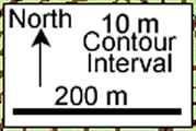 Keys or legends are essential for the use of topographic maps to read the distance scale or contour interval. In this example, it shows a contour of 10 m, and a scale length of 200 m. In future FGM Module exercises, you will need to enter scale length information.
| < Previous | 1 | 2 | 3 | 4 | 5 | 6 | 7 | 8 | 9 | 10 | 11 | 12 | 13 | 14 | 15 | 16 | 17 | 18 | 19 | 20 | 21 | 22 | 23 | 24 | 25 | 26 | 27 | Next > |