
| glossary | menu | Normal | lg | hc | 1.) Fluvial Geomorphology Training Module > Explanation of Data Measurement Exercise |
| < Previous | 1 | 2 | 3 | 4 | 5 | 6 | 7 | 8 | 9 | 10 | 11 | 12 | 13 | 14 | 15 | 16 | 17 | 18 | 19 | 20 | 21 | 22 | 23 | 24 | 25 | 26 | 27 | Next > |
Explanation of Data Measurement Exercise
Exercise Objective
To assess familiarity with ImageJ features and measurement of river Reach length and watershed area.Exercise Explanation
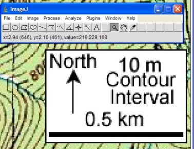
- Open, view, and zoom. With ImageJ running, and the map open, the Magnifying glass zoomed into the scale bar as shown in the first image on this page.
- Trace scale. Using the ImageJ Straight line selections (5th button from left) tool the scale bar is traced by holding the left mouse button down and dragging the mouse.
- Set scale. Using the ImageJ Menu > Analyze > Set Scale... option the scale is set by entering the "Known Distance" of 0.5, and the "Unit of Length" as km, as shown in the lower image on this page.
- Focus on river. Using ImageJ, the image is sized to focus on the river by right clicking on the Magnifying glass and Scrolling tool hand.
- Trace river. Using the ImageJ Segmented line selections tool the river length is traced. At the end of the river, double left click to end the selection.
- Measure river. Using the ImageJ Menu > Analyze > Measure (Ctrl+M) the river length is read as about 0.9 km, as shown in the lower image on this page.
- Focus on watershed. Using ImageJ, the image is sized to focus on the watershed by right clicking on the Magnifying glass and Scrolling tool hand.
- Trace watershed. Using ImageJ Polygon selections or Freehand selections tool (3rd and 4th buttons from left), the watershed can be traced. Drag the cursor perpendicular to the Elevation contours.
- Measure watershed. Using the ImageJ Menu > Analyze > Measure (Ctrl+M) the watershed area is read as about 1.0 sq km, as shown in the lower image on this page. A detailed outline of the watershed is shown on this link.
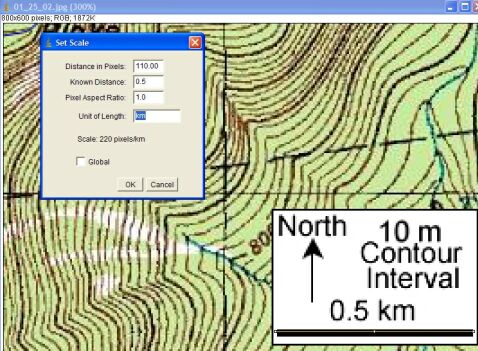
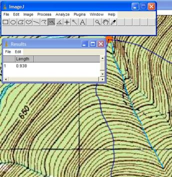
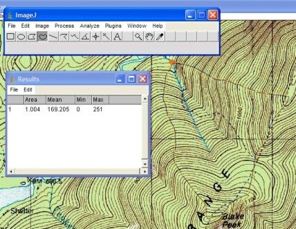
Image courtesy of USGS
| < Previous | 1 | 2 | 3 | 4 | 5 | 6 | 7 | 8 | 9 | 10 | 11 | 12 | 13 | 14 | 15 | 16 | 17 | 18 | 19 | 20 | 21 | 22 | 23 | 24 | 25 | 26 | 27 | Next > |